There are two ways to enjoy the beauty of Coumshingaun Lough, Co Waterford. One is to take a four-hour Coumshingaun loop trail, and the other is to hike straight to the shore.
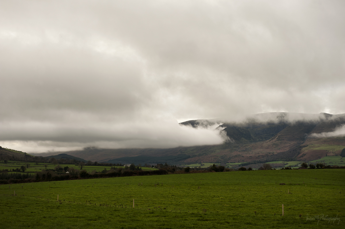
On my way to the Comeragh mountains I can see what the situation is and make a change in my plans, if necessary. It seems we will be all right today. Get ready:)
The starting point is Kilclooney Wood car park on the R676. It is roughly a 40 minutes drive from Waterford city. You can also park at the opposite side of the road and at any appropriate place, just make sure you are not obstructing the road and blocking any gates.
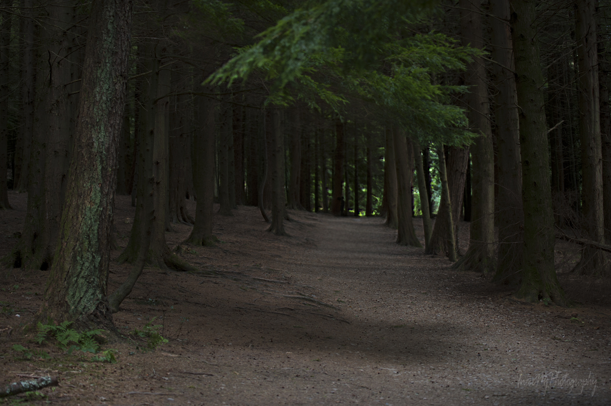
Walking through this dark and quiet part of the forest is one of my favorites, especially on the way back.
We join a forest road and turn right.

Finally we reach the place where the communications mast disguised as a tree used to be. In this picture, you can see the satellite antennas on the fake tree. The tree was a familiar landmark and I feel sad that it is gone and the new mast is just a mast…

At the start of our ascent, the path is steep and rocky. We might forget about photography for a while and focus on breathing instead. At least it is definitely true for me. Our first landmark is a huge rock on the skyline. To get there, we follow the track uphill, then turn sharp right, then uphill until we see the rock again, this time closer. The trail is not marked, but you won’t miss the erosion created by thousands of walking boots. To preserve the surrounding vegetation, please keep to the most distinct track.

We look back. What a view! Who can find the Lackendarra’s rock?
From here, we divide in two groups. The fit and healthy will hike to the rocky outcrop you see in the picture below, do some scramble and continue around the lake on a 4 hour loop trail.

I don’t have my own photographs from this hike. I have never put my foot on the loop trail. From here, I start sharing someone else’s materials and link them to the source. Some of the photographs can only be accessed through the links, but they are worth seeing. I chose the less-enhanced images.
This is a photograph from Reddit by user ShligoShtyle.
If you plan to brave the cliff walk some day, visit a versatile John Finn Photography blog. They have the best Walker’s Guide for the Coumshingaun cliff walk I could find, illustrated with great photography. You might find the articles from the Mountain View website very helpful too. Unfortunately, there are many misleading copy-and-paste web pages. Sometimes I have a feeling that the author is writing about something else because nothing resembles the real place. And I think a “travel writer and photographer” (allegedly working for the Lonely Planet and The Washington Post) is expected to use their own photographs for their blog, not the free Google images. At least one 😉 At least of a car park 😉
Another two photographs by Paul Hynes and Asia can be found on Google maps – I cannot share them here but they are stunning. Just click on the names.
I love this video about the Coumshingaun loop hike. Please ‘like’ and subscribe – the man is doing a great job in this difficult time.
About the pronunciation. There are two ways to spell the name of the lake. COUMSHINGAUN is the official one, and COMSHINAUN is a local name, known from the centuries ago ( information from Barry Dalby of East West Mapping). The name is pronounced like [com-shi-non] with the [shi] like in ‘ship’. It is the only pronunciation I know.
In my previous blog post I mentioned my conversation with a lone hiker, Garreth. He told me about his friend who run the 4 hour long loop trail in an hour… Visiting the Trail Runners web page left me in awe. I did more research and came across another website – Irish Mountain Running Association. Oh my goodness, these people are real!
I share a photograph of Scott Jurek, ultramarathoner and author who run the Coumshingaun loop trail on his visit to Ireland back in 2016. I had no idea the man existed before I did my research for this blog post. Thank you, Garreth! The photograph was posted by Mr. Jurek on his Facebook page on Tuesday, 29 march 2016. What an amazing human!

Those of you who won’t run or even hike the Coumshingaun loop, stay with me and we will have a good time simply hiking to the shore.
Keep to the track, don’t try to find a shorter way. There is none.

A look back.

We are getting closer to the coum. There is a beautiful pool of water, a miniature lake. The river bed was almost dry when the picture was taken.

Another look back.

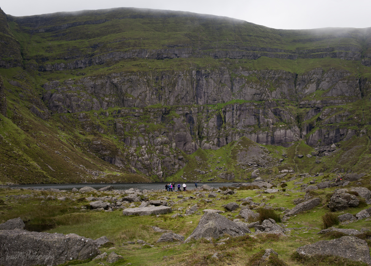
Notice the tiny hikers to get a sense of scale.

A group of hikers on the north outcrop are finishing the loop. I want to remind you again – keep to the most distinct track.


We are nearly there. Sometimes the sky is clear, but not this time. Clouds can be dangerous when hiking the loop. Have your mobile phone charged in case you have to be rescued, and stay put until you can see your path. Accidents are not unheard of here. Even on this easy trail one can get injured.

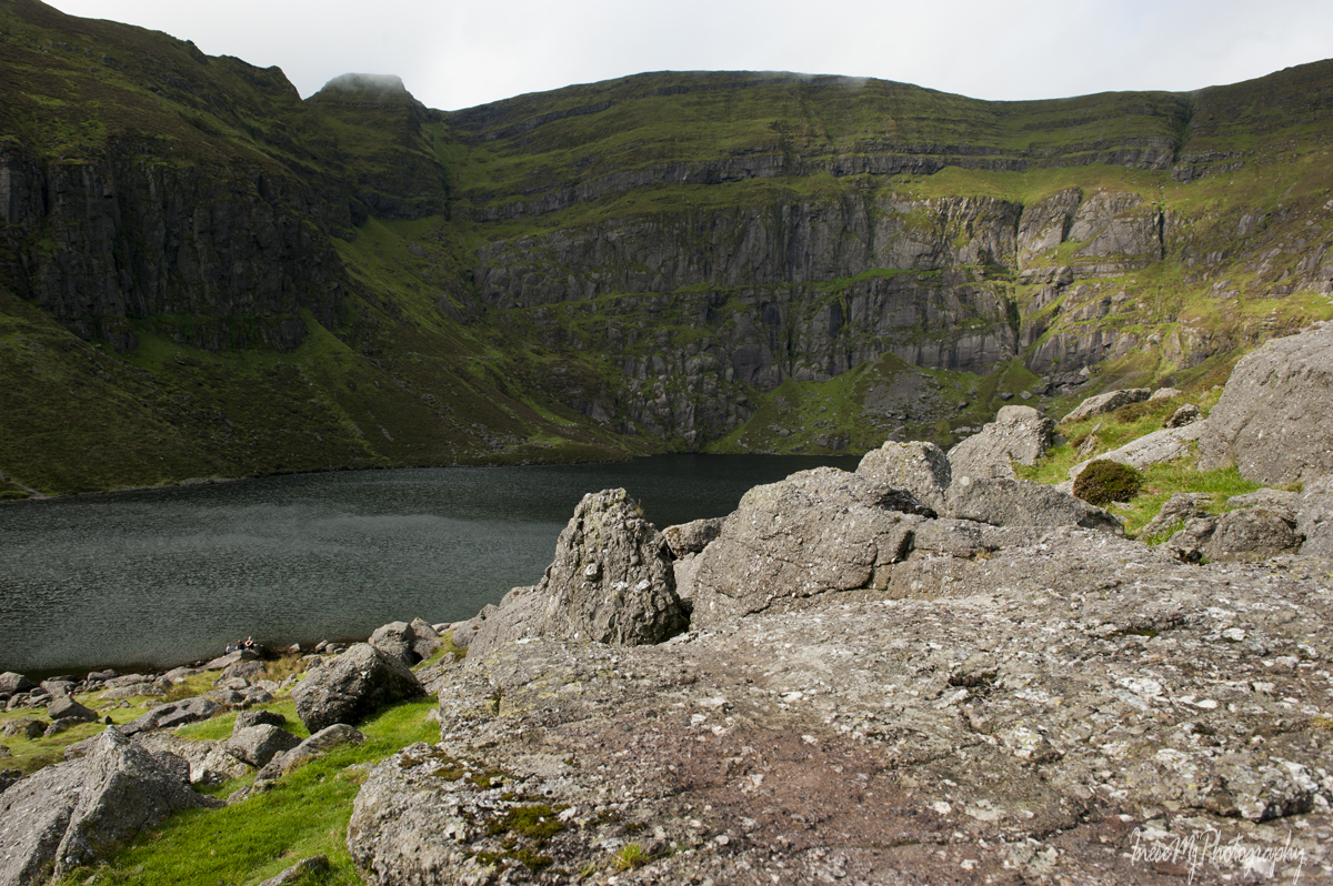
Finally there!

The cliffs behind the lake rise vertically from the dark waters to an awe inspiring 1200 feet!
Detailed information about the rock (for the seasoned rock climbers) can be found here.
It is difficult to tell the size of the lake from this point. The cliffs are gigantic and seem to be very close. In fact, the lake is about half a mile long!
As to the lake’s depth – watch the video that was mentioned in the previous video I just shared.
So now we know that the lake is 164 ft/ 50 m deep. Thanks, guys!
I hear a sound and look up. An airplane! I wonder if the author of the Grounded video is back to work?

A little about the sounds in the coum – which is a natural amphitheatre. There is an echo. Also, if a bird crosses above, you will hear a buzz created by the feathers, a very loud sound that is difficult to describe. You might hear some bits of conversations between the hikers on the slopes. Every sound is loud and clear, but it probably depends on exact location of the speaker and the listener.

We hike a little higher to get a better view of the lake. As I already told you, we, the unfit, can have as much fun as anyone else here at the Coumshingaun lake.
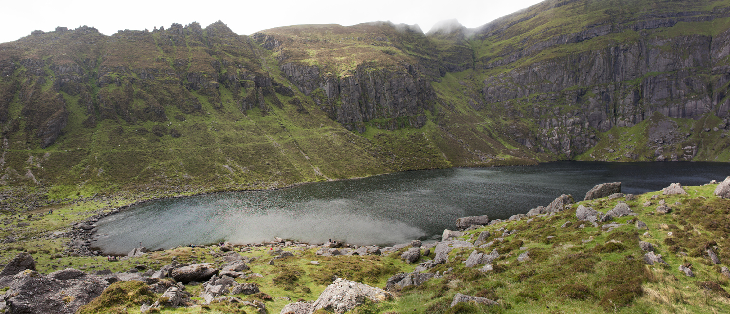
Some people even swim here, but I heard that the water is very cold. In a windy day the water is constantly rippled in different directions. The lake looks alive. It is a dark lake, but not the ink black like Bay Lough I wrote about.

This is the Crotty’s horse cave and Lackendarra’s summer residence. I never made it that far.


What goes up, must come down 😉 We begin our return journey.

The force of gravity works in the opposite way now. It is pulling us down the slope, and we have to resist and keep our balance. The balance is quite important for me as I have a heavy camera bag on my shoulder. We take short steps sometimes walking sideways. This is a beautiful slope facing south-east, sunlit for most of the day.

We can watch sheep and birds, take pictures of the timeless hawthorn trees in no hurry now. On a sunny weekend there are many other hikers. If you enjoy solitude, choose the worst weather, like I did on my last visit when I was on my own at the lake for almost an hour.
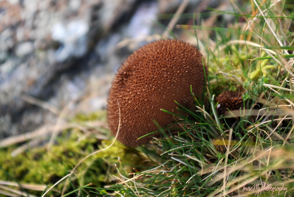
This is a picture of an Umber-brown puffball. Nothing special about it except that it was taken in December 😉 There is also a baby puffball. I only discovered it when uploaded the picture.
A Golden waxcap, picture taken on the same hike.

Lackendarra would pick up this piece of wool and stuff it in his pillowcase.

This is the last stretch of our hike, the steep rocky path that nearly gave me a blackout on the ascent when I first visited the lake. It is a piece of cake on the way down though. I look forward to climbing the steps and walking all the way through the wood: my car is parked at the end of the road. This walk is a lovely conclusion of a great hike we had today. I hope you watched the terrific videos and didn’t have any accidents during the hike 😉

Thank you very much for being my hiking companions!
 Have a great week!

I was not in the best of spirits when I encountered this post a few days back. So I had saved this post to savour it in leisure, perhaps when my soul tormented by the clamour of everyday life had calmed down enough, and I am happy I did that. Your photographs stand head and shoulders above the crowd I come upon the web, in exposure, framing and atmosphere they convey to the reader, pulling them in deeper and deeper. I was fascinated by the video of the grounded airline pilot and I wonder if I am even half fit as him to climb atop the rim of the Coumshingaun Lough (and like him, I too wonder if it is a Mandarin name somehow but not sure why). The guys measuring the depth of the lake are funny and adventurous to the core. Thank you, ever, for all those precious outings.
Thank you so much for your visit and kind words, Uma. Watching other people climb the cliffs is as engaging as climbing yourself:) I have watched all the videos about this trail. I have visualised the hike in my mind’s eye. Yet, I have enough common sense to understand that the steep incline can easily kill me. There are other ways to enjoy the beauty of the mountains.
I am not a landscape photographer. Have never been. These pictures are here to illustrate the content:) I see something beautiful – I make a composition. All credits go to Ireland:)
Fabulous view and photos!
Thank you, Nilla!
Gorgeous photos! Nature at its best! And fun videos.
Thank you! Glad you like them:)
Thank you for the mention!
Amazing photos! Will return soon to read your comments.
Thank you, Jason!
Made it back to read your commentary sooner than anticipated. It’s as though all the photos have changed and come to life in a new way! Inese, I believe you are in much better shape than ya thinks; that was quite a feat by the looks of it. Keep up the good work!
Thank you, Jason! You are right, there is nothing wrong with my legs 😉 I can walk miles.
But I would walk 500 miles
And I would walk 500 more
Just to be the man who walked a thousand miles
To fall down at your door 😉
🙂
What a wonderful place to hike! Its beautiful xx
Thank you! It sure is. Cannot wait when I can drive around again.
Beautiful Inese! Stunning.
I’m somehow a bit tired from the walk though. Lol, didn’t even have to leave my chair.
Oh Resa, you might need a gentle massage and a glass of wine 😉
The wine will do it! lol
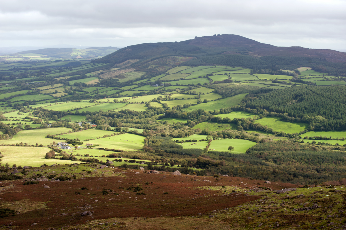
What a magnificent place, Inese. Coumshinguan Lough is exquisite with the openness and cliffs, beautiful rocks. But wow does it ever look steep and challenging to hike. You did a great job with your photos demonstrating perspective and how huge the area is. I like that photo of the dark forest road and can see why you would like it. Thanks for sharing this beautiful place in the world.
Thank you so much, Jet! I wish I could hike the loop, but this kind of hike is out of my league at the moment. You noticed that the area is huge, so there is always a room for adventure for a person of almost any level of fitness. If someone cannot make it to the lake, they can use the beautiful forest road for a walk. Thank you for being a great hiking companion!
Great adventure, magnificent report, stunning shots ❤️❤️❤️
Big hugs!
Sid
Wowee!! Inese, a joy to join you on the hike – from the comfort of my chair! 😀 The views are breathtaking and sublime. I so would love to do this for real. As for pronounciation of Irish place names has to be when the boss and I were lost in Dublin looking for dun laoghaire. Two people looked at disgust as I asked them and walked away. The third was utterly bemused and then said the name – properly. I’d literally pronounced it as it is spelt! One of those moments I wish the earth had opened up! I love Ireland SO much – wonderful people and amazing scenery! Can’t wait to return!
Annika, yes, Dun Laoghaire [dun-leary] is something you wouldn’t expect to hear 😉 Oh I so hope we can travel in 2022! I think I will get on my knees at the boarding gate and cry 😉
Me … usually I’m nearly crying out of fear of flying, but next time I travel it will be sheer delight and wonder at it all! Two beautiful summer houses in Sweden are waiting and in July it will be two years since we were there!
Oh Annika, it is heartbreaking. I am so very sorry. I agree with you about the reversed emotions. I will love my first flight too.
This has been a tremendous waste of time and mental effort. It could be put to a better use.
omg, beautiful view!
Beautiful country but I don’t think I’ll attempt pronouncing those names anytime soon! Maybe we I get to Ireland, my heritage will kick in!
Some day, some day!
Wow for a beautiful day, as you had there Inese 😀
I would love to follow you at such a beautiful hike, but I’m not sure to be able to do this. Thank you for sharing your trip here.
Thank you, Irene! It is a 45-60 minute hike, no rush, young children and dogs do it. The initial ascent is the most difficult, but it is just a few minutes long. I will write more about the place in the future.
I’m looking forward to your follow up, Inese.
Thank you!:)