
Kilmore Quay, Co Wexford, is a fishing village from where you would take a boat to travel over to Great Saltee.
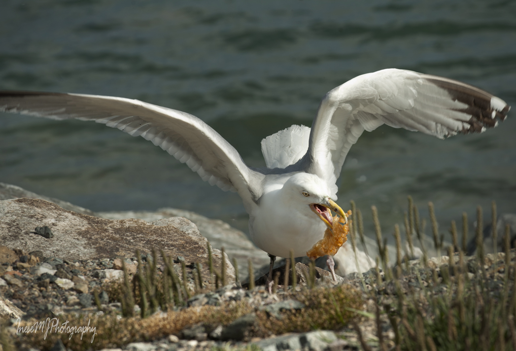
Seabirds here are foraging around the fishing vessels and chippers. See who is lucky today? This Great black backed gull got a crab, and the Herring gull – a chunk of battered fish.

Before we begin our walk, please watch this 2 minute ‘bird eye’ video, and visit this web page to look through the colorful pictures 🙂
We will take a short walk just to see a glimpse of what Killmore Quay has to offer, and I plan on writing more blogs in the future.
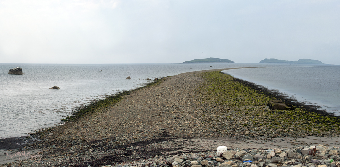
At low tide we walk east from the marina along the shingle beach to St. Patrick’s Bridge, a natural bouldery gravel causeway, glacial deposit where the real St. Patrick has probably never set foot – though legends say different. He was chasing the Devil who took a bite of a mountain in Tipperery, The Devil’s Bite mountain. I am planning to go there this year as a part of a project. Anyway, the Devil quickly realised that he had bit more than he could chew and spat the Rock of Cashel, but St. Patrick kept chasing him and throwing rocks at him until he was gone under the water. It is how the Bridge and Saltee islands were formed.

A product of the last Ice Age, St. Patrick’s Bridge is believed to be a moraine. The boulders you see in the picture below are so-called erratics, very large boulders of a rock type that is not found locally, which means they were carried by the ice. The biggest erratic is seen on the left, and has a name – St. Patrick’s Rock. Naturally 🙂
In the 18th century, local fishermen started building a safe haven to moor their boats. They collected the rocks from St. Patrick’s Bridge and transported them to the village where the rocks were piled to create an L-shape barrier – a predecessor of the harbour we know today. The first pier was constructed in the mid 19th century, and the major redevelopment took place in the 1990s.
Centuries pass by but St. Patrick’s Bridge still curves out to Little Saltee, and they say that “no stones are washed from it”.
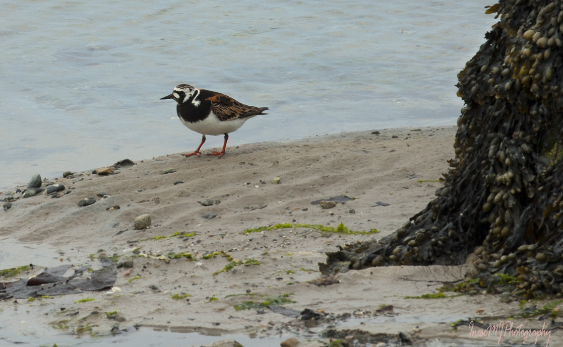
I spotted a Ruddy turnstone on my way back to the marina.
There are two different formations in Kilmore Quay which are often confused one for another in photographs. St. Patrick’s Bridge is the one on the right (East) from marina, and the Forlorn Point causeway is on the left (West).

Storm Ophelia that hit Ireland in 2017, unearthed an ancient body at Forlorn Point. The body was once buried there, not washed up by the sea.

A herring gull landed on the old boat.

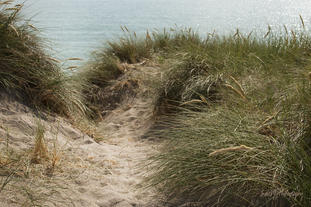
Unnamed C.92 is navigating the sea of grass these days.

Past Forlorn Point, overlooking Ballyteigue Bay there stands a sculpture depicting a grieving couple. The stretch of sea from the Hook Head to Tuskar Rock, is called Graveyard of a thousand ships. And not only ships. Aer Lingus flight 712 went down into the sea off Tuskar Rock when en route from Cork to London on 24 March 1968, killing all 61 people on board. A cause of the crash was never determined, and only 14 bodies were recovered.
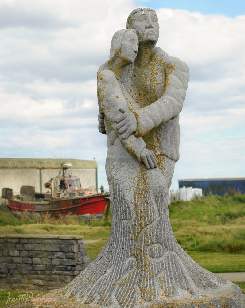
Remembrance Garden is dedicated to the memory of those lost at sea. Some families have no graveside to visit. They can come and grieve for their loved ones here, in this beautiful peaceful place.
The garden incorporates a propeller blade from the SS Lennox sunk off the Saltee Islands in 1916. Her crew was saved by the Kilmore lifeboat.

When the promenade ends, we step on a path that takes us to Ballyteige Burrow – a natural treasure of County Wexford.

I didn’t have much time that day. At the first opportunity I crossed the dunes towards the sea and after 50 min was back at the Remembrance Garden. This map is to show you all the 9 km of the narrow coastal townland consisting of a series of sand dunes and hollows, and circled is the part I have walked across.
Ballyteige Burrow dunes are 2000 years old.

Why ‘burrow’? The townland was managed as a rabbit warren for over 600 years. Rabbits are not native to Ireland. The Normans brought them as a source of protein for their armies.
The sand dunes include embryo dunes, shifting dunes and fixed dunes, each with their own type of vegetation. Coastal flora is diverse, even though it doesn’t look so from the first sight because many plant species are tiny and hidden in the grasses. March orchid is the most spectacular flower that will catch your eye.

Sea bindweed is different from the familiar Field bindweed – the leaves are small and fleshy, and the trumpet is vivid pink. They call it The Prince’s flower.

In this picture you also see the green stems of Prickly saltwort.

On my way I take many photographs and make a few compositions that will be put to use in the future.

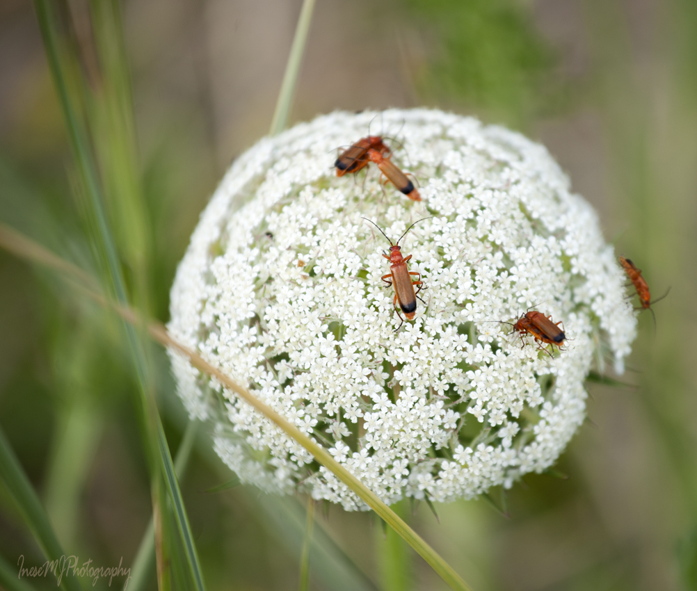
Sea carrot is hosting a wild Red soldier beetle party.
I wouldn’t notice the tiny Burnet rose, not higher than 4 inches, if not for the bright shiny hips.

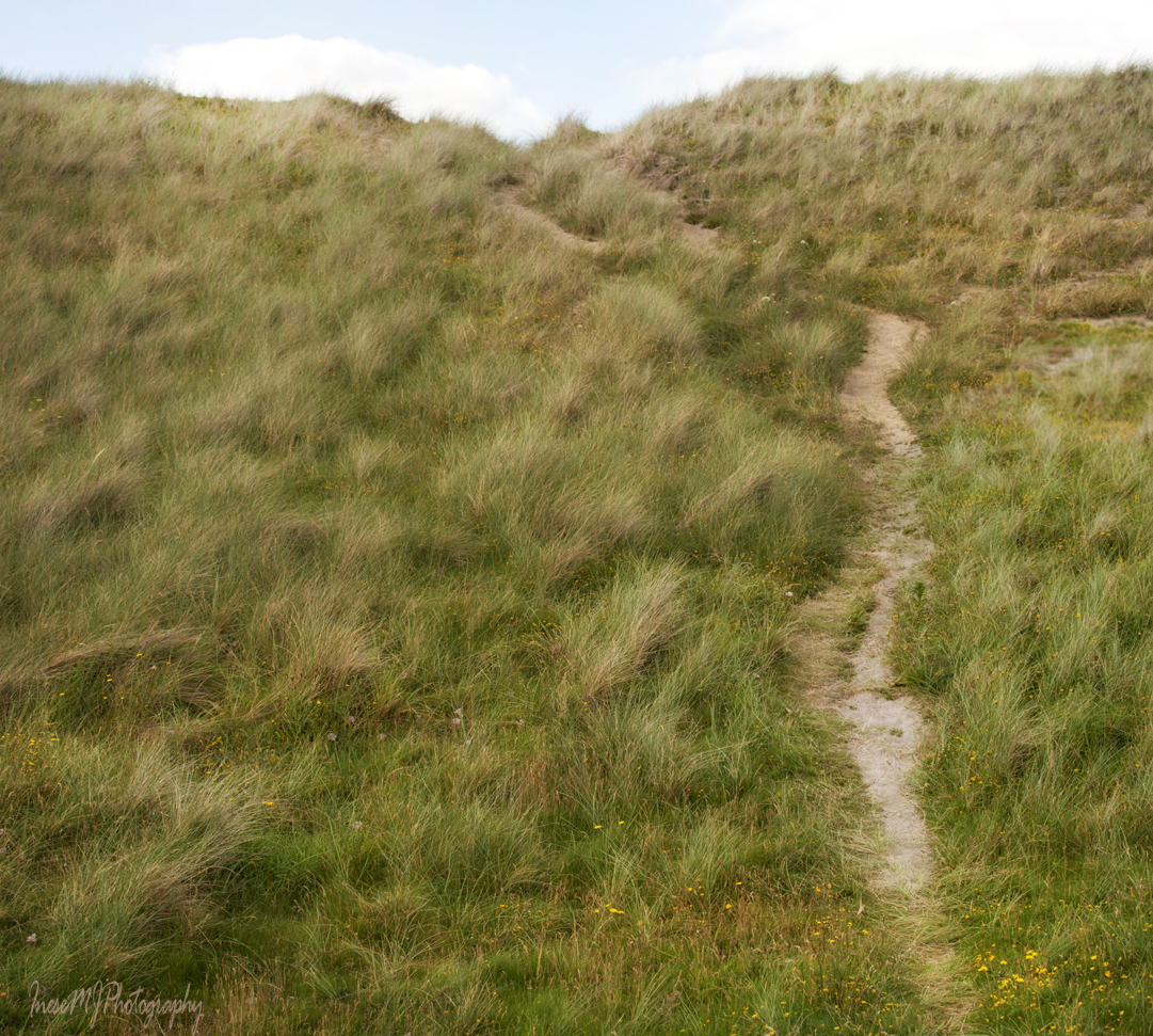
The path is not paved, but it is distinct and probably used by both humans and wildlife. It doesn’t go straight to the sea. Instead, it is winding between the dunes, up and down. Breathless I get to the top only to see another dune. Well, even if we get lost, the longest we have to walk is 9 km ( 6 miles). Phew 😉
We can see far away from the top of a high dune. Ballyteige Castle in the picture below was built by Sir Walter de Whitty, a Norman settler. It is a typical tower-house built to protect the household. Members of the Whitty family managed the rabbit warren at Ballyteige Burrow.
The roofs of Kilmore hidden behind a fixed dune.

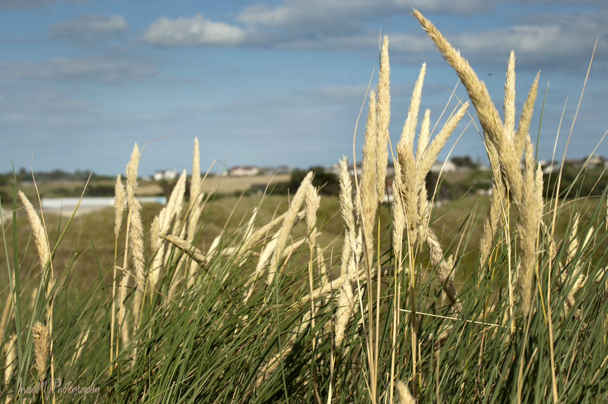
Marram grass.
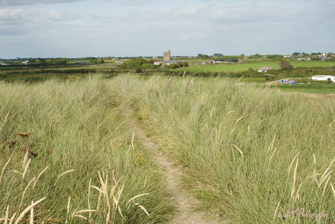
Vegetation is changing, and we can feel the fresh breeze – the sea is near, at last.


This view is so Wexford!

The beach looks deserted apart from a small tent pitched in the sand. Some other time we will walk all the 6 miles, but today we turn east and walk back to the marina car park.

A huge piece of kelp with rhizoids washed up in the sand. Here is a good website Galloway Wild Foods for those who is interested in foraging. I am too tired to pick up the heavy kelp.

The Forlorn Point looks close but it takes another 15 minutes to get there – walking on soft sand is, well, hard.

This picture was taken from the Great Saltee. The seagull’s bill points straight to the Forlorn Point, and the beach and dunes are on the left hand side.

This is the Great Saltee as you see it from the Forlorn Point. Our trip is complete, at least for today.

One more bird shot before we leave Kilmore Quay.

Here is the last video to summarize your day 🙂 Thank you for joining the walk. See you in a week at Spraoi 2019 street festival!
 Have a wonderful weekend!

Hello Inese,
Another wonderful series, informative, with stunning images. Like many others, I appreciate your generosity in sharing some of your travels with us. I can imagine the love and effort required to put together a post like this ❤
Best wishes,
Takami
Thank you so much, Takami! ❤ I only want to remind the readers that there are beautiful things to see just around the corner, in the neighboring town, in their own country. Making memories doesn't necessarily mean spending your whole life traveling the world 🙂 I do post a 'foreign' blog once or twice a year, but I do love my local discoveries 🙂
Your blog is always an inspiration! ❤
Yes, it is as you say! There are many “discoveries” around the corner, if only we pay attention 🙂 Many thanks as always ❤
Look forward to the new adventures of the Grebe family 🙂
I love that memorial statue. It’s just fabulous. Forlorn point, what a great name.
Thank you! 🙂 The statue is wonderful.
What a lovely trip, Inese. It has all, nature, wildlife, history and fresh air. The image of the seagull vs the crab got me – the animal kingdom has its own rule 🙂
Thank you Indah! The crab was stolen from the fishing boat 🙂 The seagulls are very opportunistic 🙂
Nice post, including videos, blog, and photos!
Thank you so much!
You’re welcome!
A lovely walk Inese, with wonderful photos and pictures. Amazing that Patrick’s bridge has remained intact for so many centuries too.
Loved the coastal flowers, best wishes
Julian
Thank you! Yes, it is amazing. The bridge continues under water and can be crossed by boat in some marked places. The currents are very dangerous in this area.
Coastal flora is very special.
a beautiful, old fishing village holiday, inese!
looks like the birdies are quite good
at catching, also 🙂
Thank you! I guess the crab was stolen from a boat 🙂
What a lovely walk, Inese! Beautiful land meets sea pictures and video; loved the music and seeing the dog there. So meaningful, what sadness in the Remembrance Garden.
Thank you so much! There is a stone with the names. Some families have lost 2-3 generations to the sea. Many bodies have never been recovered, and this garden gives the families a place to grieve and remember.
These waters are deadly, and called The grave of thousand ships for a good reason.
Fascinating and love the old boat!
Thank you! The boat is something!
What an enjoyable walk, Inese! You bring it to life, not only with your excellent photos, but also with the stories you tell about the place and its history. I love the legend about St. Patrick and the Devil: so much more exciting than the scientific geological explanation. In this serene landscape of open farmlands, sky, and expansive sea, Remembrance Garden is a sad reminder that Death finds us where It will and cares not for the pain and loss left in It’s wake.
Thank you Rosaliene! This legend is not trustworthy: the origin of almost every island around Ireland has been tracked to that mountain-biting episode 🙂
Thank you for the lovely historical and peaceful Walk!,
Thank you! It was peaceful indeed – I had the dunes and beach all to myself. Walking is quite difficult there, and the dog owners prefer the well beaten track on the other side of the dunes.
Lucky you!
I was lucky indeed. The dunes is a favorite place for the naturist/nudist gatherings. May be it is the reason why the locals don’t walk around there 🙂
Lol. Maybe!
Beautiful photos as always 🙂
Thank you!
Thanks for the great walk – I always feel a lot healthier for the exercise!! Loved the photos of the derelict boat in the grass!
Thank you for joining the walk 🙂 I was trying to learn more about the boat, but people I asked had no clue. Probably just another fishing boat with no particular story.
What a wonderful tour you’ve given us. Thank you. 😊
Thank you for joining the walk! 🙂
That was wonderful.
I was in Co Wexford a couple of years ago, and Kilmore Quay looks familiar…..
This is the village from where the boat goes to the puffin island 🙂 Thatched houses, good seafood, lovely atmosphere.
It was pouring with rain, and we didn’t stop there….
Oh that rain!
😊😊
More excellent photographs and fascinating history. I hadn’t known about the skeleton. I particularly liked the kelp lighting
Thank you Derrick! That skeleton had skin on it. Guess it was preserved in the salty environment. Some Dublin scientists took it away and we never heard from it again since 🙂
The chunk of kelp was gigantic and very photogenic 🙂
Beautiful visit Inese and thank you for sharing your great photos and stories about the places 🙂
Wish you a beautiful weekend.
Thank you so much, Irene! Glad you joined the walk! 🙂
I did 🙂
❤
What a lovely post. When I read your posts, and all your history of these places and see your beautiful photographs I so feel I am walking along that road.
Thank you! I came from the place where almost everything was leveled during the WW2, and I am excited about every piece of history on offer, wherever I go 🙂
I know you have come from some hard times in your family so I don’t blame you. What great history it is too xxx
Beautiful place; beautiful photographs. Looking at them reminded me how I miss sand dunes in parts of the Devon coast. Everything is chalk here. I like it but I like memories as well ~ George
Oh I cannot even imagine a chalk seashore. Wexford beaches are lovely.
A very nice walking with you to this place. Love the videos especially the musics that go along with them. Wonderful.
Thank you! I thought the ‘bird view’ would be helpful 🙂